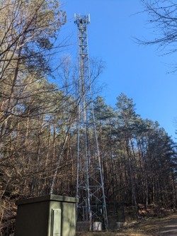
Chemin vers Pulverbruecke Buergerwald 67340 Lichtenberg
Créé le 30/11/2023
2 photos • 1 test effectué • 36 cellules enregistrées
| 2G | 3G | 4G | 5G | ||
|---|---|---|---|---|---|
Informations ANFR


Adresse ANFR
chemin vers Pulverbruecke BUERGERWALD 67340 Lichtenberg
gNB • eNB • RNC
N/A • 1033060 • 992
TAC / LAC
61696 / 3992
Code ANFR
0670990429
Support ID
2745325
Code Insee
67265
Hauteur
36m
Nature
Pylône autostable
Propriétaire
SFR
GPS
48.93333333,7.49666667
Date accord implantation
24/11/2023
Date modification
-
Date activation
29/03/2024
Secteurs
| Panneau | 34.7 m. | 45° |
| Panneau | 34.7 m. | 135° |
| Panneau | 34.7 m. | 265° |
FH
Opérateurs
Pylône autostable (36 m)
Informations Arcep
Free Mobile
Num OP
67265_001
ID site partagé
ZPG67428
Région
Grand Est
Département
Bas-Rhin (67)
Commune
Lichtenberg (67265)
Site 2G
Site 3G
Site 4G
Site 5G
Equipement 4G dernier trimestre
Site programme "Zones Blanches"
Site programme "Dispositif de Couverture Ciblée"
Site programme "France Mobile"
Site capacité théorique >= à 240 Mbs
Date première ouverture commerciale 5G
Site 5G 700 MHz
Site 5G 800 MHz
Site 5G 1800 MHz
Site 5G 2100 MHz
Site 5G 3500 MHz